iGeology
British Geological Survey

Free Grades: 9 to 12
Downloads: 10,000-50,000
Num. Ratings: 99 DescriptioniGeology - Interactive geological mapping of the UK. iGeology is for anyone who wants to explore their local geology, at street-level scale, virtually anywhere in the UK. Amateur geologists, walkers and gardeners can look at whatTMs in their local area, to find out about the rocks at the surface (superficial deposits) or the bedrock beneath. Search on place names or the postcode where you live, then click on the map and reveal the rocks beneath your feet. iGeology will locate your phone (if GPS is enabled) and zoom to your location. Drag the person icon onto the map for a 3D view of the geological landscape. The maps use the British Geological SurveyTMs national scale (1:625 000) and LandrangerTM scale (1:50 000) geological datasets of the United Kingdom (UK). Map coverage 5% of 1:50000 scale data is unavailable for England, Scotland and Wales. Only 1:625 000 scale data is available for Northern Ireland. iGeology is intended for non-commercial use e.g. private study, research and educational activities. For commercial use of BGS data email: [email protected] Recent changes: New 3D view of the geological landscape. New historical geology map overlay. Improved geological descriptions. Cached map image files hidden from the Android Gallery. Move app to SD card enabled. Content rating: Low Maturity Screenshots 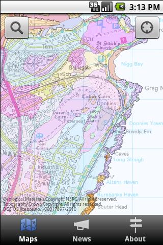 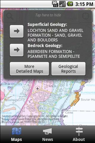 Comments Log in to rate this app!Sort by: Highest Rating | Lowest Rating 
by scipio
- 05/08/2012
Brilliant and easier to use than a geological mapUsing Scroll Excel with Android 4. Easy to zoom to street level. To find out what the map colours signify just rest your finger on the part you are interested in and a description of the type of geological formation pops up. It usually offers you a link to even more data about the formation, albeit in technical geology speak. But then this is an app from the British Geological Survey so I would expect it to be technical. In response to some earlier comments I have had no issues with my gallery, having played with this all afternoon. [Edit: Well I have now! I also found a long list of random blurred geology pictures when using my file manager. However I used a different file manager and I could not find them? It appears that some file managers confuse the cache with the gallery! I have since found an identical effect with OS maps. The setting menu on my Scroll Excel gives the option of clearing the cache for each application so that is an easy option if it worries you.]
by Paul
- 04/04/2012
UninstallingFilled my gallery with folders called '1', '2' etc - each containing random snapshots of bits of geological maps at crazy angles. Left a message at BGS by doing their online survey..
by Väiski
- 03/24/2012
ExcellentExcellent app for amature & pro geologist, students & land users.
by Chris
- 03/20/2012
Excellent field guideHandy little field guide to UK geology. Could benefit from another zoom level, but it's free, so I shouldn't complain.
by Anonymous
- 03/08/2012
Pretty neat.Would benefit from slightly greater zoom.
by David
- 02/05/2012
Free gps geology mapping with linked key to rocks. Better than paper
by Richard
- 01/29/2012
Good app
by Kiu
- 01/09/2012
Geologic time scaleThe Google Map of UK Geology. Would be nice to have a Geologic time scale in it. By far all other geologic time scale apps on Android are using American terminologies.
by Chilli
- 11/22/2011
BGSGeology Rocks!!!
by Philippe
- 11/11/2011
Great on the field.Really useful and easy to use. Great portal to BGS.
View More... |

Register | Invite | Vendors | Report Issue | Contact Us | About Us | Login
Digital Wish is a U.S. 501 (c)3 non-profit organization.